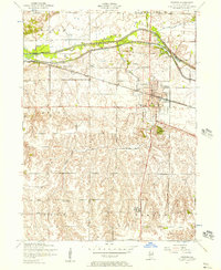
1953 Map of Geneseo
USGS Topo · Published 1957About this map
The town of Geneseo sits at the intersection of mid-century rail and water infrastructure, dominated by the Chicago Rock Island and Pacific railroad line. To the north, the landscape is defined by the Green River and the engineering of the Illinois and Mississippi Canal (abandoned), where Lock No 25 remains a clear landmark of the region's earlier waterway transport era. This survey, conducted just after the war, captures a rural landscape still dotted with local educational landmarks such as Andrews School, Hart School, and Wildermuth School. The transition from the flatlands around the Big Slough Drainage Ditch to the more dissected terrain along Geneseo Creek illustrates the complex drainage and agricultural management of central Henry County. Significant local sites like the Illinois Fish Hatchery and Oakwood Cemetery provide grounding for family historians researching this period of Illinois history.
Find a feature on this map
24 named features on this map. Tap any name to fly to it.
Don’t see what you’re looking for? This feature index may not catch every label — zoom into the map to look around manually.
Map Details
Editions of this 1953 Geneseo Map
2 editions found
Other maps of this area

1892 · Leclaire
USGS Topo · 1:62,500

1893 · Leclaire
USGS Topo · 1:62,500

1899 · Clinton
USGS Topo · 1:125,000

1934 · Geneseo
USGS Topo · 1:62,500

1937 · Orion
USGS Topo · 1:62,500

1949 · Port Byron
USGS Topo · 1:24,000

1950 · Port Byron
USGS Topo · 1:24,000

1952 · Erie
USGS Topo · 1:62,500
1953 · Port Byron
USGS Topo · 1:24,000

1953 · German Corner
USGS Topo · 1:24,000