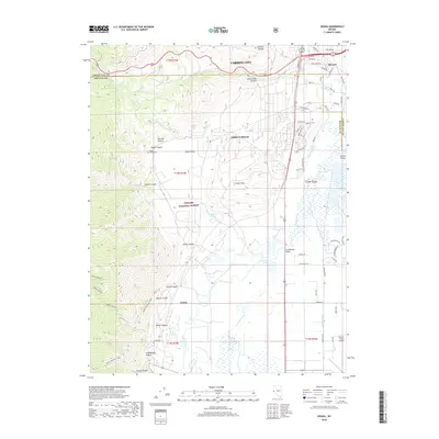
2018 Map of Genoa
USGS Topo · Published 2018About this map
The settlement of Genoa, Nevada's oldest permanent settlement, lies at the base of the eastern Sierra Nevada where the high desert meets the irrigated pastures of the Carson Valley. This 2018 survey documents the interface between the historic town center and the modern residential expansions of Indian Hills. The geography is defined by a series of steep canyons—including Adams Canyon, Sierra Canyon, and Genoa Canyon—that drain into the Carson River basin. Agricultural legacies remain visible through the complex network of waterways like the Heyburn Ditch and Williams Slough, which support the low-lying valley lands. To the north, the map records the transitions at the border of Carson City, where Stewart and the Clear Creek Canyon area show significant suburban development. Local heritage is marked by the Genoa Cem and Jacks Valley Cem, while the Cradlebaugh Bridge serves as a critical river crossing near Ambrosetti Pond.
Find a feature on this map
64 named features on this map. Tap any name to fly to it.
Don’t see what you’re looking for? This feature index may not catch every label — zoom into the map to look around manually.
Map Details
Editions of this 2018 Genoa Map
This is the sole edition of this map. No revisions or reprints were ever made.
Other maps of this area

1889 · Markleeville
USGS Topo · 1:125,000

1891 · Carson
USGS Topo · 1:125,000

1891 · Markleeville
USGS Topo · 1:125,000

1893 · Carson
USGS Topo · 1:125,000

1893 · Markleeville
USGS Topo · 1:125,000

1948 · Walker Lake
USGS Topo · 1:250,000

1955 · Bijou
USGS Topo · 1:24,000

1955 · Marlette Lake
USGS Topo · 1:24,000

1955 · Glenbrook
USGS Topo · 1:24,000

1956 · Freel Peak
USGS Topo · 1:62,500