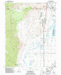
1994 Map of Genoa
USGS Topo · Published 1994About this map
The Carson Range forms a dramatic backdrop for Genoa, Nevada’s oldest permanent settlement, which remains a focal point on this 1994 update. The township area includes the Morman Station Historic State Mon, documenting the roots of the state's pioneer history near the base of Genoa Canyon. To the north, the terrain transitions into the broad expanse of Jacks Valley, where the Jacks Valley Cem and several spring-fed features like Hobo Hot Springs mark the landscape.
Find a feature on this map
51 named features on this map. Tap any name to fly to it.
Don’t see what you’re looking for? This feature index may not catch every label — zoom into the map to look around manually.
Map Details
Editions of this 1994 Genoa Map
This is the sole edition of this map. No revisions or reprints were ever made.
Other maps of this area

1889 · Markleeville
USGS Topo · 1:125,000

1891 · Carson
USGS Topo · 1:125,000

1891 · Markleeville
USGS Topo · 1:125,000

1893 · Carson
USGS Topo · 1:125,000

1893 · Markleeville
USGS Topo · 1:125,000

1948 · Walker Lake
USGS Topo · 1:250,000

1955 · Bijou
USGS Topo · 1:24,000

1955 · Marlette Lake
USGS Topo · 1:24,000

1955 · Glenbrook
USGS Topo · 1:24,000

1956 · Freel Peak
USGS Topo · 1:62,500