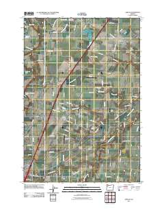
2011 Map of Gervais
USGS Topo · Published 2011About this map
Gervais and its surrounding agricultural plains appear here in the early 21st century, defined by a network of drainage canals and small rail-side settlements. The landscape is heavily marked by its pioneer history, evidenced by the numerous burial grounds scattered across the valley, including Pioneers Cemetery, Saint Louis Cemetery, and the Skunkville Cemetery. The agricultural importance of the region is anchored by the Fairfield Grange and the proximity of the Little Pudding River. Small community hubs like Saint Louis, Brooks, and Hazel Green are connected by a grid of named roads such as Saint Louis Rd NE and Checkerboard Rd NE. The presence of several private landing strips, including Harchenko Industrial Airfield and Hollin Airfield, highlights the modern utility of these rural lands. To the south, the terrain descends toward Lake Labish and the settlement of Chemawa, reflecting the drainage patterns that have shaped this portion of Marion County.
Find a feature on this map
82 named features on this map. Tap any name to fly to it.
Don’t see what you’re looking for? This feature index may not catch every label — zoom into the map to look around manually.
Map Details
Editions of this 2011 Gervais Map
This is the sole edition of this map. No revisions or reprints were ever made.
Other maps of this area

1915 · Eola
USGS Topo · 1:31,680

1917 · Salem
USGS Topo · 1:62,500

1923 · Mount Angel
USGS Topo · 1:62,500

1924 · Mc Minnville
USGS Topo · 1:48,000

1925 · Stayton
USGS Topo · 1:62,500

1926 · Mc Minnville
USGS Topo · 1:62,500

1940 · McMinnville
USGS Topo · 1:62,500

1940 · Salem
USGS Topo · 1:62,500

1940 · Mount Angel
USGS Topo · 1:62,500

1941 · Stayton
USGS Topo · 1:62,500