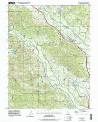
1997 Map of Geyserville
USGS Topo · Published 1998About this map
The Alexander Valley floor defines the northeastern portion of this study, where the Russian River winds through a landscape established by late-twentieth-century viticulture and agriculture. Centered on the community of Geyserville, the map details a complex network of transportation and infrastructure, including the Northwestern Pacific railroad corridor and numerous river crossings. To the west, the terrain rises sharply toward Bradford Mountain, cut by the deep drainage of Dry Creek.
Find a feature on this map
64 named features on this map. Tap any name to fly to it.
Don’t see what you’re looking for? This feature index may not catch every label — zoom into the map to look around manually.
Map Details
Editions of this 1997 Geyserville Map
This is the sole edition of this map. No revisions or reprints were ever made.
Other maps of this area

1920 · Healdsburg
USGS Topo · 1:62,500

1921 · Skaggs
USGS Topo · 1:62,500

1921 · Kelseyville
USGS Topo · 1:62,500

1933 · Healdsburg
USGS Topo · 1:48,000

1938 · Hopland
USGS Topo · 1:62,500

1940 · Healdsburg
USGS Topo · 1:62,500

1943 · Cazadero
USGS Topo · 1:24,000

1943 · Skaggs Springs
USGS Topo · 1:24,000

1943 · Kelseyville
USGS Topo · 1:62,500

1943 · Hopland
USGS Topo · 1:62,500