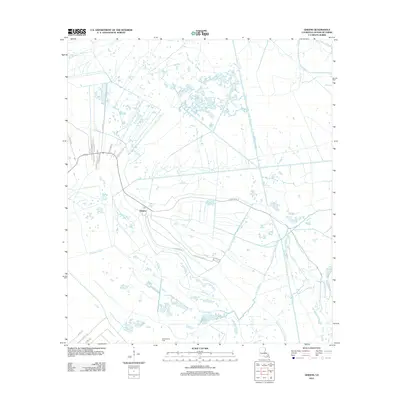
2012 Map of Gheens
USGS Topo · Published 2012About this map
The settlement of Gheens serves as the focal point of this coastal Louisiana landscape, characterized by a complex network of natural waterways and man-made canals. Transportation and drainage patterns are defined by features such as the Company Canal and the Forty-Arpent-Canal, which reflect the historical engineering required to manage the low-lying terrain of Lafourche Parish. The local economy is grounded in the extraction industry, evidenced by the presence of the Valentine Oil Field to the south.
Find a feature on this map
26 named features on this map. Tap any name to fly to it.
Don’t see what you’re looking for? This feature index may not catch every label — zoom into the map to look around manually.
Map Details
Editions of this 2012 Gheens Map
This is the sole edition of this map. No revisions or reprints were ever made.
Other maps of this area

1891 · Hahnville
USGS Topo · 1:62,500

1892 · Lac Des Allemands
USGS Topo · 1:62,500

1892 · Cut-Off
USGS Topo · 1:62,500

1892 · Houma
USGS Topo · 1:62,500

1932 · Houma SE
USGS Topo · 1:31,680

1932 · Lac Des Allemands SE
USGS Topo · 1:31,680

1932 · Houma NE
USGS Topo · 1:31,680

1932 · Hahnville SW
USGS Topo · 1:31,680

1939 · Cut-Off
USGS Topo · 1:62,500
1939 · Houma
USGS Topo · 1:62,500