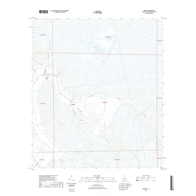
2018 Map of Gheens
USGS Topo · Published 2018About this map
Gheens serves as the central hub of this coastal Lafourche Parish landscape, where the intersection of Gheens Main Rd and Sugar Mill Rd reflects a local economy historically tied to the land. The community is defined by a dense network of waterways and drainage infrastructure, with the Company Canal and Forty Arpent Canal cutting through the wetlands. These engineered channels exist alongside winding natural features like Bayou Vacherie and Petit Bois Bayou. The residential layout is clustered along specific corridors such as Cypress Villa Ln and N Leon Dr, while the surrounding geography is dominated by vast marshlands. Notable bayous like Bayou Chateau de Cypre and Bayou Matherne snake through the terrain, illustrating the delicate balance of habitation and water management in this low-lying region.
Find a feature on this map
31 named features on this map. Tap any name to fly to it.
Don’t see what you’re looking for? This feature index may not catch every label — zoom into the map to look around manually.
Map Details
Editions of this 2018 Gheens Map
This is the sole edition of this map. No revisions or reprints were ever made.
Other maps of this area

1891 · Hahnville
USGS Topo · 1:62,500

1892 · Lac Des Allemands
USGS Topo · 1:62,500

1892 · Cut-Off
USGS Topo · 1:62,500

1892 · Houma
USGS Topo · 1:62,500

1932 · Houma SE
USGS Topo · 1:31,680

1932 · Lac Des Allemands SE
USGS Topo · 1:31,680

1932 · Houma NE
USGS Topo · 1:31,680

1932 · Hahnville SW
USGS Topo · 1:31,680

1939 · Cut-Off
USGS Topo · 1:62,500
1939 · Houma
USGS Topo · 1:62,500