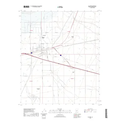
2018 Map of Gila Bend
USGS Topo · Published 2018About this map
Gila Bend serves as a vital desert crossroads where the Gila River meets an extensive network of washes and canals. This 2018 survey illustrates the modern layout of the town, featuring residential enclaves like San Lucy Village and Burleson Park alongside critical infrastructure. The map details the proximity of the Gila Bend Municipal Airport and the sprawling Gila Bend Air Force Auxiliary Airport to the south, highlighting the area's strategic aviation importance. Researchers can trace the path of the Gila Bend Canal as it provides irrigation across the Sonoran Desert landscape. Local history is anchored by markers such as Pioneer Cem and the Stout Cem, while the historic route of the Butterfield Trl cuts through the desert floor, following the alignment of modern transportation corridors.
Find a feature on this map
67 named features on this map. Tap any name to fly to it.
Don’t see what you’re looking for? This feature index may not catch every label — zoom into the map to look around manually.
Map Details
Editions of this 2018 Gila Bend Map
This is the sole edition of this map. No revisions or reprints were ever made.
Other maps of this area

1950 · Theba
USGS Topo · 1:62,500

1951 · Gila Bend
USGS Topo · 1:62,500

1951 · Theba
USGS Topo · 1:62,500

1951 · Cotton Center
USGS Topo · 1:62,500

1951 · Woolsey Peak
USGS Topo · 1:62,500

1953 · Ajo
USGS Topo · 1:250,000

1954 · Phoenix
USGS Topo · 1:250,000

1957 · Ajo
USGS Topo · 1:250,000

1957 · Phoenix
USGS Topo · 1:250,000

1958 · Ajo
USGS Topo · 1:250,000
Featured Places
- Gila Bend, AZ
- San Lucy District, AZ
- San Lucy Village, San Lucy District
- Maricopa County, AZ
- United States