1909 Map of Gilbert
USGS Topo · Published 1909About this map
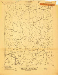
The Guyandot River winds through this 1909 survey, anchoring a landscape of steep hollows and expanding coal-country settlements. The Norfolk and Western railway follows the river's bend at the southern edge of the sheet, connecting industrial outposts like Wharncliffe, Alnwick, and War Eagle. This era represents a significant transition for the region, as the topography is defined by dozens of family-named drainage features like Pound Mill Br and Sugartree Br that reveal the domestic patterns of the early 20th century. Local travel is marked by the Northspring Road and the passage through Twisted Gun Gap, while high points like Coon Knob and Panther Knob overlook the developing hamlets of Gilbert and Hanover. The map meticulously records numerous county boundaries, including where Mingo and Pike counties meet the state lines of Kentucky and Virginia.
Find a feature on this map
148 named features on this map. Tap any name to fly to it.
Don’t see what you’re looking for? This feature index may not catch every label — zoom into the map to look around manually.
Map Details
Editions of this 1909 Gilbert Map
This is the sole edition of this map. No revisions or reprints were ever made.
Other maps of this area

1886 · Grundy
USGS Topo · 1:125,000

1887 · Warfield
USGS Topo · 1:125,000

1890 · Grundy
USGS Topo · 1:125,000

1891 · Tazewell
USGS Topo · 1:125,000

1891 · Oceana
USGS Topo · 1:125,000

1891 · Warfield
USGS Topo · 1:125,000

1892 · Grundy
USGS Topo · 1:125,000

1893 · Oceana
USGS Topo · 1:125,000

1895 · Tazewell
USGS Topo · 1:125,000

1897 · Tazewell
USGS Topo · 1:125,000