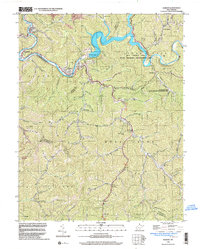
1996 Map of Gilbert
USGS Topo · Published 2003About this map
The Guyandotte River carves a winding path through the coal-rich mountains of West Virginia, dominated by the waters of the R D Bailey Lake and its associated R D Bailey Dam. This late-twentieth-century landscape is defined by the intersection of industrial activity and conservation, with extensive Mines and Gas Wells appearing alongside the R D Bailey Lake State Wildlife Management Area. Settlements like Gilbert, Justice, and Sprattsville follow the river's course, while Ikes Fork and Hanover sit tucked into the narrow valleys further south.
Find a feature on this map
73 named features on this map. Tap any name to fly to it.
Don’t see what you’re looking for? This feature index may not catch every label — zoom into the map to look around manually.
Map Details
Editions of this 1996 Gilbert Map
This is the sole edition of this map. No revisions or reprints were ever made.
Other maps of this area

1891 · Tazewell
USGS Topo · 1:125,000

1891 · Oceana
USGS Topo · 1:125,000

1893 · Oceana
USGS Topo · 1:125,000

1895 · Tazewell
USGS Topo · 1:125,000

1897 · Tazewell
USGS Topo · 1:125,000

1898 · Oceana
USGS Topo · 1:125,000

1909 · Gilbert
USGS Topo · 1:48,000

1910 · Pineville
USGS Topo · 1:48,000

1910 · Iaeger
USGS Topo · 1:48,000

1912 · Gilbert
USGS Topo · 1:62,500