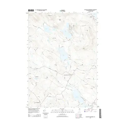
2015 Map of Gilmanton Ironworks
USGS Topo · Published 2015About this map
Gilmanton Ironworks and the smaller settlement of Lower Gilmanton anchor this 2015 survey of the Belknap County landscape. The topography is defined by the southeastern reaches of the Belknap Mountains, including peaks like Goat Pasture Hill and Pine Mtn. The region is densely interconnected by a network of waterways and glacial lakes, notably Crystal Lake and the twin reservoirs of Upper Suncook Lake and Lower Suncook Lake, which feed the Suncook River.
Find a feature on this map
109 named features on this map. Tap any name to fly to it.
Don’t see what you’re looking for? This feature index may not catch every label — zoom into the map to look around manually.
Map Details
Editions of this 2015 Gilmanton Ironworks Map
This is the sole edition of this map. No revisions or reprints were ever made.
Other maps of this area

1909 · Winnepesaukee
USGS Topo · 1:62,500

1919 · Gilmanton
USGS Topo · 1:62,500

1919 · Alton
USGS Topo · 1:62,500

1927 · Gilmanton
USGS Topo · 1:62,500

1928 · Wolfeboro
USGS Topo · 1:62,500

1949 · Portland
USGS Topo · 1:250,000

1956 · Winnipesaukee
USGS Topo · 1:62,500

1956 · Portland
USGS Topo · 1:250,000

1957 · Alton
USGS Topo · 1:62,500
1957 · Gilmanton
USGS Topo · 1:62,500