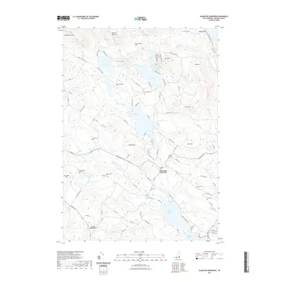
2021 Map of Gilmanton Ironworks
USGS Topo · Published 2021About this map
Gilmanton Ironworks serves as the focal point of this Belknap County landscape, situated where the Suncook River flows south from Sunset Lake. The area's complex topography is defined by the Belknap Mountains in the northwest and a series of prominent heights including Cogswell Mtn and Rocky Mtn. This modern survey details a region characterized by numerous glacial lakes and ponds, from the clusters of Manning Lake and Lake Eileen to the larger basins of Upper Suncook Lake and Lower Suncook Lake. Local genealogy and historical settlement patterns are preserved through several burial grounds, such as the Smith Meeting House Cem near Lower Gilmanton and the Pickering Lot Cem. The network of backroads, including Places Mill Rd and Guinea Ridge Rd, traces the historic routes between these highland communities and their water-powered industry sites.
Find a feature on this map
105 named features on this map. Tap any name to fly to it.
Don’t see what you’re looking for? This feature index may not catch every label — zoom into the map to look around manually.
Map Details
Editions of this 2021 Gilmanton Ironworks Map
This is the sole edition of this map. No revisions or reprints were ever made.
Other maps of this area

1909 · Winnepesaukee
USGS Topo · 1:62,500

1919 · Gilmanton
USGS Topo · 1:62,500

1919 · Alton
USGS Topo · 1:62,500

1927 · Gilmanton
USGS Topo · 1:62,500

1928 · Wolfeboro
USGS Topo · 1:62,500

1949 · Portland
USGS Topo · 1:250,000

1956 · Winnipesaukee
USGS Topo · 1:62,500

1956 · Portland
USGS Topo · 1:250,000

1957 · Alton
USGS Topo · 1:62,500
1957 · Gilmanton
USGS Topo · 1:62,500