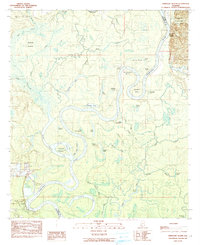
1984 Map of Ginhouse Island
USGS Topo · Published 1984About this map
The Tombigbee River carves a complex path through the Alabama bottomlands, defining the border between Washington and Clarke counties. This fluvial landscape is dominated by extreme meanders and oxbow features like Horseshoe Bend and Newman Bend, where the river’s historical shifts have created numerous isolated landforms. Named for the cotton processing that once anchored the river economy, Ginhouse Island sits surrounded by the waters of Three Rivers Lake and Otter Bayou.
Find a feature on this map
51 named features on this map. Tap any name to fly to it.
Don’t see what you’re looking for? This feature index may not catch every label — zoom into the map to look around manually.
Map Details
Editions of this 1984 Ginhouse Island Map
This is the sole edition of this map. No revisions or reprints were ever made.
Other maps of this area

1943 · Choctaw Bluff
USGS Topo · 1:62,500

1943 · Tensaw
USGS Topo · 1:62,500

1943 · Citronelle
USGS Topo · 1:62,500

1943 · McIntosh
USGS Topo · 1:62,500

1944 · McIntosh
USGS Topo · 1:62,500

1944 · Tensaw
USGS Topo · 1:62,500

1946 · Citronelle
USGS Topo · 1:62,500

1946 · Choctaw Bluff
USGS Topo · 1:62,500

1953 · Andalusia
USGS Topo · 1:250,000

1953 · Hattiesburg
USGS Topo · 1:250,000