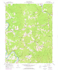
1957 Map of Girta
USGS Topo · Published 1977About this map
Little Kanawha River and Hughes River define the winding, ridge-heavy landscape of Wirt and Ritchie counties in the late 1950s. The region is marked by a legacy of early resource extraction, with numerous Oil Wells peppered across the valleys of Standingstone Creek and the Burning Springs Oil Field. Small rural settlements and family landmarks anchor the hills, including Girta and the riverside communities of Enterprise and Saratoga. Educational and spiritual life is evident through a network of isolated sites like Oil Rock Sch, Owl Hill Sch, and Wesleyan Chapel. Prominent high points such as Ruble Knob and Owl Hill overlook a complex drainage system where Flint Run and Oil Rock Run have carved deep into the terrain, reflecting the era's reliance on local natural features for navigation and community structure.
Find a feature on this map
82 named features on this map. Tap any name to fly to it.
Don’t see what you’re looking for? This feature index may not catch every label — zoom into the map to look around manually.
Map Details
Editions of this 1957 Girta Map
4 editions found
Other maps of this area

1906 · Elizabeth
USGS Topo · 1:62,500

1907 · Harrisville
USGS Topo · 1:62,500

1907 · Arnoldsburg
USGS Topo · 1:62,500

1907 · Spencer
USGS Topo · 1:62,500

1924 · Harrisville
USGS Topo · 1:62,500

1924 · Elizabeth
USGS Topo · 1:62,500

1925 · Arnoldsburg
USGS Topo · 1:62,500

1926 · Elizabeth
USGS Topo · 1:62,500

1926 · Harrisville
USGS Topo · 1:62,500

1927 · Arnoldsburg
USGS Topo · 1:62,500