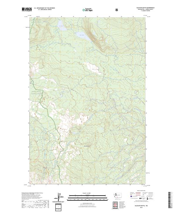
2023 Map of Glaciate Butte
USGS Topo · Published 2023About this map
Glaciate Butte rises as the central landmark in this high-altitude landscape of Yakima County, where the alpine terrain is carved by the Muddy Fork and Clearwater Creek. The area is defined by its status as protected land, split between the Gifford Pinchot National Forest and the Mount Adams Wilderness. The presence of Foggy Flat and the eponymous Two Lakes in the northern reaches suggests a glacially influenced topography typical of the Cascades. Transportation in this remote environment is limited to unpaved forestry and bureau routes like Mount Adams Lake Rd and Bia RD 108, alongside recreational paths such as the Highline Trl. The map illustrates the headwaters of numerous drainages, including Trappers Creek and Little Muddy Creek, which feed the regional watershed.
Find a feature on this map
16 named features on this map. Tap any name to fly to it.
Don’t see what you’re looking for? This feature index may not catch every label — zoom into the map to look around manually.
Map Details
Editions of this 2023 Glaciate Butte Map
This is the sole edition of this map. No revisions or reprints were ever made.
Other maps of this area

1904 · Mount Adams
USGS Topo · 1:125,000

1907 · Mount Adams
USGS Topo · 1:125,000

1926 · Steamboat Mtn
USGS Topo · 1:125,000

1931 · Steamboat Mtn
USGS Topo · 1:125,000

1950 · Yakima
USGS Topo · 1:250,000

1958 · Yakima
USGS Topo · 1:250,000

1961 · Yakima
USGS Topo · 1:250,000
1970 · Hamilton Buttes
USGS Topo · 1:24,000
1970 · Walupt Lake
USGS Topo · 1:24,000
1970 · Mount Adams West
USGS Topo · 1:24,000