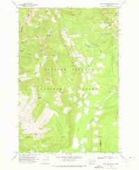
1970 Map of Hamilton Buttes
USGS Topo · Published 1973About this map
Gifford Pinchot National Forest dominates this topographic survey, revealing the remote high-country terrain of the Washington Cascades as it was documented in 1970. The landscape is defined by the drainage systems of the Cispus River and its North Fork, which carve through steep ridges like Stonewall Ridge and Mission Mtn. Navigation during this era relied heavily on an extensive network of a Pack Trail, providing access to isolated water bodies such as St John Lake, St Michael Lake, and Hugo Lake. In the northeast, the map transitions into the high elevations of the Goat Rocks Wilderness, where Goat Ridge stands as a prominent landmark. The presence of a small Gravel Pit and several campgrounds near Chambers Lake indicates the limited human infrastructure and resource management present at the time, while the tri-county boundary where Lewis, Skamania, and Yakima counties meet highlights the remote geopolitical convergence in this forested region.
Find a feature on this map
29 named features on this map. Tap any name to fly to it.
Don’t see what you’re looking for? This feature index may not catch every label — zoom into the map to look around manually.
Map Details
Editions of this 1970 Hamilton Buttes Map
This is the sole edition of this map. No revisions or reprints were ever made.
Other maps of this area

1902 · Mount Aix
USGS Topo · 1:125,000

1904 · Mt Aix
USGS Topo · 1:125,000

1904 · Mount Adams
USGS Topo · 1:125,000

1907 · Mount Adams
USGS Topo · 1:125,000

1924 · Mt Rainier
USGS Topo · 1:96,000

1926 · Steamboat Mtn
USGS Topo · 1:125,000

1928 · Mt Rainier
USGS Topo · 1:125,000

1931 · Steamboat Mtn
USGS Topo · 1:125,000

1950 · Yakima
USGS Topo · 1:250,000

1958 · Yakima
USGS Topo · 1:250,000