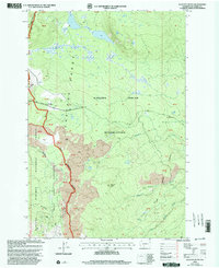
1998 Map of Glaciate Butte
USGS Topo · Published 2003About this map
The Yakama Indian Reservation boundary defines much of this terrain, meeting the Gifford Pinchot National Forest in a landscape dominated by volcanic remnants and high-elevation water sources. The map reveals an area where the Cascade Range crest intersects with the Mount Adams Wilderness, highlighted by extensive fields of Lava that flow toward the drainage of Little Muddy Creek. Significant for recreation and management, the area includes the Potato Hill Guard Station near Potato Hill and the Highline Trail traversing the western slopes. The presence of Two Lakes and the headwaters of Clearwater Creek illustrate the vital alpine watershed during this period of late-twentieth-century forest administration. Researchers can trace the network of forest access via Potato Hill Road and identify specific land management units marked by protracted block boundaries.
Find a feature on this map
34 named features on this map. Tap any name to fly to it.
Don’t see what you’re looking for? This feature index may not catch every label — zoom into the map to look around manually.
Map Details
Editions of this 1998 Glaciate Butte Map
This is the sole edition of this map. No revisions or reprints were ever made.
Other maps of this area

1904 · Mount Adams
USGS Topo · 1:125,000

1907 · Mount Adams
USGS Topo · 1:125,000

1926 · Steamboat Mtn
USGS Topo · 1:125,000

1931 · Steamboat Mtn
USGS Topo · 1:125,000

1950 · Yakima
USGS Topo · 1:250,000

1958 · Yakima
USGS Topo · 1:250,000

1961 · Yakima
USGS Topo · 1:250,000
1970 · Hamilton Buttes
USGS Topo · 1:24,000
1970 · Walupt Lake
USGS Topo · 1:24,000
1970 · Mount Adams West
USGS Topo · 1:24,000