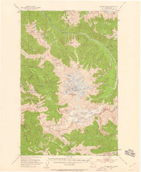
1950 Map of Glacier Peak
USGS Topo · Published 1959About this map
Glacier Peak dominates this 1950 aerial survey of the Cascade Range, showing a complex network of active ice fields including the Suiattle Glacier, White Chuck Glacier, and Ptarmigan Glacier. The map records the high-altitude infrastructure of the mid-century, featuring backcountry outposts such as the Suiattle Guard Sta. and the Kennedy Hot Springs Guard Station. The landscape is defined by the dividing line between the Mount Baker National Forest and the Wenatchee National Forest.
Find a feature on this map
87 named features on this map. Tap any name to fly to it.
Don’t see what you’re looking for? This feature index may not catch every label — zoom into the map to look around manually.
Map Details
Editions of this 1950 Glacier Peak Map
4 editions found

Other maps of this area

1899 · Glacier Peak
USGS Topo · 1:125,000

1901 · Glacier Peak
USGS Topo · 1:125,000

1901 · Chiwaukum
USGS Topo · 1:125,000

1902 · Skykomish
USGS Topo · 1:125,000

1902 · Stehekin
USGS Topo · 1:125,000

1904 · Stehekin
USGS Topo · 1:125,000

1904 · Chiwaukum
USGS Topo · 1:125,000

1905 · Skykomish
USGS Topo · 1:125,000

1944 · Holden
USGS Topo · 1:62,500

1949 · Holden
USGS Topo · 1:62,500