
1928 Map of Glastonbury
USGS Topo · Published 1928About this map
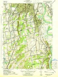
The Connecticut River forms the western boundary of this landscape, its banks defining the early settlement patterns of Hartford County in the late 1920s. This survey, compiled from aerial photographs by the Air Corps, reveals a transitional environment where established villages like Glastonbury and Naubuc serve as anchors between the river and the rising elevations to the east. The terrain transitions from the low-lying valley floors near Pewterpot Brook to the prominent heights of Minnechaug Mtn and Meshomasic Mtn. Numerous smaller hamlets, including Addison, Buckingham, and Hopewell, are shown situated along the drainages of Salmon Brook and Roaring Brook. The map captures the distinct boundary between Hartford and Middlesex Counties, providing a clear look at the agricultural and residential layout of Glastonbury before modern suburban expansion reshaped the region.
Find a feature on this map
24 named features on this map. Tap any name to fly to it.
Don’t see what you’re looking for? This feature index may not catch every label — zoom into the map to look around manually.
Map Details
Editions of this 1928 Glastonbury Map
This is the sole edition of this map. No revisions or reprints were ever made.
Other maps of this area

1892 · Hartford
USGS Topo · 1:62,500

1892 · Tolland
USGS Topo · 1:62,500

1892 · Gilead
USGS Topo · 1:62,500

1893 · Middletown
USGS Topo · 1:62,500

1906 · Farmington
USGS Topo · 1:125,000

1921 · Tolland
USGS Topo · 1:62,500

1928 · Cromwell
USGS Topo · 1:24,000

1928 · Windsor
USGS Topo · 1:24,000

1928 · Manchester
USGS Topo · 1:24,000
1944 · Hartford South
USGS Topo · 1:31,680