
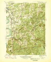
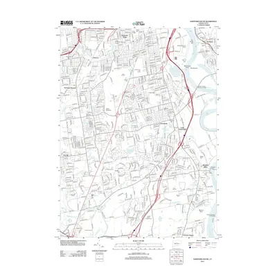
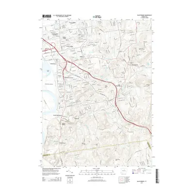
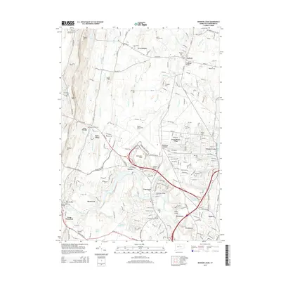
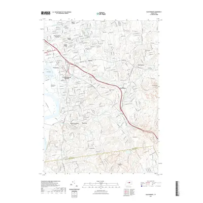
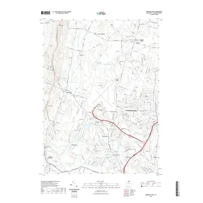
1946 Map of Glastonbury
USGS Topo · Published 1946About this map
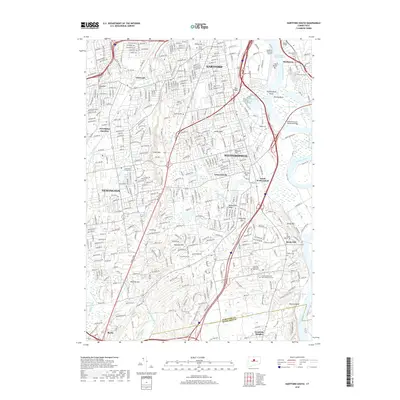
Glastonbury and its neighboring villages are mapped here during the mid-1940s, revealing a landscape defined by the winding Connecticut River and the high ridges of Minnechaug Mtn and Kongscut Mtn. The area is notably dense with early burial grounds, including the Glastonbury Green Cem, Old Church Cem, and Still Hill Cem, providing a rich resource for genealogical research. Settlement patterns follow the historical transportation corridors, most notably along the New London Turnpike as it cuts through the hills toward the southeast. Small industrial and agricultural hamlets like Addison, Hopewell, and South Glastonbury are well-defined, while the presence of a Quarry near the Hartford Co Middlesex Co line points to local industry. From the Glastonbury Meadows to the high elevations of Meshomasic Mtn, the map captures the transition from riverine agriculture to the wooded uplands of central Connecticut.
Find a feature on this map
60 named features on this map. Tap any name to fly to it.
Don’t see what you’re looking for? This feature index may not catch every label — zoom into the map to look around manually.
Map Details
Editions of this 1946 Glastonbury Map
2 editions found
Historical Maps of Manchester Through Time
54 maps found

1892 Granby
Hartford County, CT

1906 Farmington
Hartford County, CT

1928 Glastonbury
Hartford County, CT

1928 Manchester
Hartford County, CT

1928 Mittineague
Hartford County, CT

1928 Windsor
Hartford County, CT

1928 Windsor Locks
Hartford County, CT

1944 Hartford South
Hartford County, CT

1944 Manchester
Hartford County, CT

1945 Hartford North
Hartford County, CT
1946 Glastonbury
Hartford County, CT

1946 Windsor Locks
Hartford County, CT

1951 Avon
Hartford County, CT

1952 Hartford North
Hartford County, CT

1952 Hartford South
Hartford County, CT

1952 Manchester
Hartford County, CT

1953 Glastonbury
Hartford County, CT

1953 Windsor Locks
Hartford County, CT

1957 Avon
Hartford County, CT

1963 Manchester
Hartford County, CT

1964 Glastonbury
Hartford County, CT

1964 Hartford North
Hartford County, CT

1964 Hartford South
Hartford County, CT

1964 Windsor Locks
Hartford County, CT
2012 Avon
Hartford County, CT
2012 Glastonbury
Hartford County, CT
2012 Hartford North
Hartford County, CT
2012 Hartford South
Hartford County, CT
2012 Manchester
Hartford County, CT
2012 Windsor Locks
Hartford County, CT
2015 Avon
Hartford County, CT
2015 Glastonbury
Hartford County, CT
2015 Hartford North
Hartford County, CT
2015 Hartford South
Hartford County, CT
2015 Manchester
Hartford County, CT
2015 Windsor Locks
Hartford County, CT
2018 Avon
Hartford County, CT
2018 Glastonbury
Hartford County, CT
2018 Hartford North
Hartford County, CT
2018 Hartford South
Hartford County, CT
2018 Manchester
Hartford County, CT
2018 Windsor Locks
Hartford County, CT
2021 Avon
Hartford County, CT
2021 Glastonbury
Hartford County, CT
2021 Hartford North
Hartford County, CT
2021 Hartford South
Hartford County, CT
2021 Manchester
Hartford County, CT
2021 Windsor Locks
Hartford County, CT

2024 Avon
Hartford County, CT

2024 Glastonbury
Hartford County, CT

2024 Hartford North
Hartford County, CT

2024 Hartford South
Hartford County, CT

2024 Manchester
Hartford County, CT

2024 Windsor Locks
Hartford County, CT