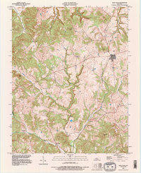
1993 Map of Glen Dean
USGS Topo · Published 1996About this map
The ridge and valley landscape of western Breckinridge County is defined here by the confluence of many small waterways, including Daniels Creek and Black Lick Creek. Small rural communities like Glen Dean and McQuady serve as the primary hubs of activity, linked by winding roads that follow the natural topography. The area is marked by numerous family and community landmarks, such as St Marys Cem and Owens Cem, which provide significant points of interest for those researching local lineage. Notable elevations like Egypt Knob and McQuady Mtn break the horizon, while a Gaging Station on one of the larger creek branches suggests the importance of water management in this agricultural region. The map also records the boundary line shared with Hancock County, illustrating the geopolitical layout of the territory during the 1990s update of this mid-century survey.
Find a feature on this map
27 named features on this map. Tap any name to fly to it.
Don’t see what you’re looking for? This feature index may not catch every label — zoom into the map to look around manually.
Map Details
Editions of this 1993 Glen Dean Map
This is the sole edition of this map. No revisions or reprints were ever made.
Other maps of this area

1928 · Hardinsburg
USGS Topo · 1:48,000

1931 · Hardinsburg
USGS Topo · 1:62,500

1932 · Fordsville
USGS Topo · 1:62,500

1934 · Cannelton
USGS Topo · 1:62,500

1947 · Hardinsburg
USGS Topo · 1:24,000

1947 · Hardinsburg
USGS Topo · 1:62,500

1953 · Mc Daniels
USGS Topo · 1:24,000

1953 · Hardinsburg
USGS Topo · 1:24,000

1953 · Kingswood
USGS Topo · 1:24,000

1953 · Cloverport
USGS Topo · 1:24,000