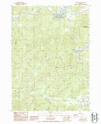
1986 Map of Glendale
USGS Topo · Published 1986About this map
The town of Glendale serves as the primary hub in this mid-1980s survey, where the waters of Cow Creek and Mill Creek meet. The map reveals a region defined by its narrow valley floors and resource extraction history, particularly along the southern reaches of the quadrangle. Significant placer mining activity is recorded through labels like Steam Beer Placer, Golf Placer, and the evocative Glory Hole Placer, providing evidence of the local gold mining heritage that persisted well after the initial frontier booms.
Find a feature on this map
41 named features on this map. Tap any name to fly to it.
Don’t see what you’re looking for? This feature index may not catch every label — zoom into the map to look around manually.
Map Details
Editions of this 1986 Glendale Map
This is the sole edition of this map. No revisions or reprints were ever made.
Other maps of this area

1904 · Riddle
USGS Topo · 1:125,000

1946 · Galice
USGS Topo · 1:62,500

1946 · Dutchman Butte
USGS Topo · 1:62,500

1948 · Galice
USGS Topo · 1:62,500

1948 · Dutchman Butte
USGS Topo · 1:62,500

1954 · Glendale
USGS Topo · 1:62,500

1954 · Canyonville
USGS Topo · 1:62,500

1955 · Medford
USGS Topo · 1:250,000

1957 · Medford
USGS Topo · 1:250,000

1958 · Medford
USGS Topo · 1:250,000