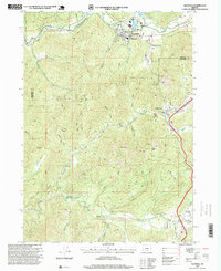
1996 Map of Glendale
USGS Topo · Published 1999About this map
Glendale and the surrounding mining districts of the southern Oregon Cascades appear here in a mid-1990s revision by the Forest Service. The terrain is deeply incised by drainages such as Cow Creek, Grave Creek, and Wolf Creek, which historically supported significant placer mining operations. Evidence of this gold-seeking history is visible in the naming of features like Steam Beer Placer, Glory Hole Placer, and Geff Placer along the creek beds. A noteworthy local landmark, the Covered Bridge, is located in the southeastern portion of the map near Sunny Valley. The landscape is dominated by steep summits including Sugarloaf, Malone Peak, and London Peak, with the boundary between Douglas and Josephine counties cutting through the center of the survey. The map also records essential infrastructure of the era, from the Sewage Disposal Plant and Substation in Glendale to the local Post Office and various schools or churches marked simply as Cemeteries.
Find a feature on this map
58 named features on this map. Tap any name to fly to it.
Don’t see what you’re looking for? This feature index may not catch every label — zoom into the map to look around manually.
Map Details
Editions of this 1996 Glendale Map
This is the sole edition of this map. No revisions or reprints were ever made.
Other maps of this area

1904 · Riddle
USGS Topo · 1:125,000

1946 · Galice
USGS Topo · 1:62,500

1946 · Dutchman Butte
USGS Topo · 1:62,500

1948 · Galice
USGS Topo · 1:62,500

1948 · Dutchman Butte
USGS Topo · 1:62,500

1954 · Glendale
USGS Topo · 1:62,500

1954 · Canyonville
USGS Topo · 1:62,500

1955 · Medford
USGS Topo · 1:250,000

1957 · Medford
USGS Topo · 1:250,000

1958 · Medford
USGS Topo · 1:250,000