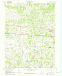
1961 Map of Glenford
USGS Topo · Published 1973About this map
The Licking and Perry County borderlands in the early 1960s are defined by the convergence of agrarian life and industrial remnants. At the heart of this landscape lies Glenford, situated near the southern junction of Jonathan Creek and the Penn Central railroad lines. To the north, the terrain rises into the distinctive Flint Ridge, a topographical feature of significant archaeological importance indicated here by a labeled Indian Mound. The map captures a network of small crossroads settlements including Linnville, Amsterdam, and Brownsville, many of which developed along the historic Base Boundary Line Refugee Lands. Local genealogy is well-supported by the presence of Ellis Chapel, Goodhope Church, and the Highland Cemetery, alongside numerous distributed oil wells that signal the region's mineral extraction history. Features like the Franklin School and the small whistle-stop of Glass Rock further illustrate the mid-century rural infrastructure.
Find a feature on this map
35 named features on this map. Tap any name to fly to it.
Don’t see what you’re looking for? This feature index may not catch every label — zoom into the map to look around manually.
Map Details
Editions of this 1961 Glenford Map
3 editions found
Other maps of this area

1909 · Newark
USGS Topo · 1:62,500

1909 · Thornville
USGS Topo · 1:62,500

1910 · Frazeysburg
USGS Topo · 1:62,500

1910 · Zanesville
USGS Topo · 1:62,500

1947 · Columbus
USGS Topo · 1:250,000

1950 · Marion
USGS Topo · 1:250,000

1961 · Columbus
USGS Topo · 1:250,000

1961 · Hanover
USGS Topo · 1:24,000

1961 · Newark
USGS Topo · 1:24,000

1961 · Rushville
USGS Topo · 1:24,000