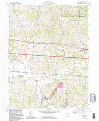
1992 Map of Glenford
USGS Topo · Published 1995About this map
Flint Ridge State Memorial Park dominates the northern corner of this Licking and Perry County landscape, marking an area of immense archaeological and geological importance. The map captures a region defined by its narrow valleys and prominent high points like Buzzard Glory Knob and Eagle Nest Hill. The intersection of historical transit and settlement is evident through the path of the North Base Boundary Line and the Refugee Lands boundary, which cut across the terrain near Linnville. Small communities such as Glenford and Brownsville serve as local hubs, while industrial activity is noted by numerous Oil Wells scattered through the hills. An Indian Mound and several rural sites like Ellis Chapel and Highland Cem provide valuable touchstones for genealogists tracing family roots in Franklin and Hopewell townships.
Find a feature on this map
29 named features on this map. Tap any name to fly to it.
Don’t see what you’re looking for? This feature index may not catch every label — zoom into the map to look around manually.
Map Details
Editions of this 1992 Glenford Map
This is the sole edition of this map. No revisions or reprints were ever made.
Other maps of this area

1909 · Newark
USGS Topo · 1:62,500

1909 · Thornville
USGS Topo · 1:62,500

1910 · Frazeysburg
USGS Topo · 1:62,500

1910 · Zanesville
USGS Topo · 1:62,500

1947 · Columbus
USGS Topo · 1:250,000

1950 · Marion
USGS Topo · 1:250,000

1961 · Columbus
USGS Topo · 1:250,000

1961 · Hanover
USGS Topo · 1:24,000

1961 · Newark
USGS Topo · 1:24,000

1961 · Rushville
USGS Topo · 1:24,000