
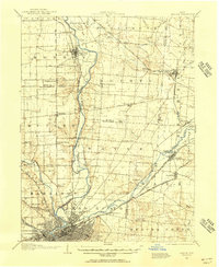
1947 Map of Columbus
USGS Topo · Published 1948About this map
Columbus and the surrounding central Ohio heartland are depicted here just after the war, showcasing a landscape defined by its major river systems and post-war aviation growth. The Scioto River and Hocking River serve as primary geographical anchors, while the remnants of the Ohio Canal and established rail corridors like the Pennsylvania RR and New York Central RR trace the region's industrial heritage. This era shows significant military installations, including the Lockbourne USAF Base south of the city and the Camp Sherman Military Reservation near Chillicothe.
Find a feature on this map
95 named features on this map. Tap any name to fly to it.
Don’t see what you’re looking for? This feature index may not catch every label — zoom into the map to look around manually.
Map Details
Editions of this 1947 Columbus Map
This is the sole edition of this map. No revisions or reprints were ever made.
Other maps of this area

1901 · Dublin
USGS Topo · 1:62,500

1902 · Westerville
USGS Topo · 1:62,500

1903 · Dublin
USGS Topo · 1:62,500

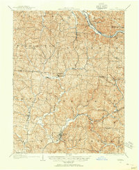
1903 · Athens
USGS Topo · 1:62,500

1904 · Westerville
USGS Topo · 1:62,500

1904 · Springfield
USGS Topo · 1:62,500
1904 · Zaleski
USGS Topo · 1:62,500
1904 · Dayton
USGS Topo · 1:62,500

1904 · Chesterhill
USGS Topo · 1:62,500

1905 · Athens
USGS Topo · 1:62,500