
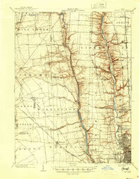
1903 Map of Dublin
USGS Topo · Published 1939About this map
The Scioto River and Olentangy River corridors dominate this central Ohio landscape, carving deep valleys through the glacial till. Surveyed at the dawn of the twentieth century, the region shows a dense network of steam railroads serving agricultural communities. Major lines including the Cleveland Cincinnati Chicago and St Louis RR and the Hocking Valley RR parallel the waterways, facilitating the growth of settlements like Worthington and Lewis Center.
Find a feature on this map
55 named features on this map. Tap any name to fly to it.
Don’t see what you’re looking for? This feature index may not catch every label — zoom into the map to look around manually.
Map Details
Editions of this 1903 Dublin Map
2 editions found
Other maps of this area

1901 · Dublin
USGS Topo · 1:62,500

1902 · Westerville
USGS Topo · 1:62,500

1904 · Westerville
USGS Topo · 1:62,500

1907 · London
USGS Topo · 1:62,500

1913 · Richwood
USGS Topo · 1:62,500

1915 · Richwood
USGS Topo · 1:62,500

1915 · Marengo
USGS Topo · 1:62,500

1916 · Milford Center
USGS Topo · 1:62,500

1923 · West Columbus
USGS Topo · 1:62,500

1924 · Delaware
USGS Topo · 1:62,500