1902 Map of Westerville
USGS Topo · Published 1958About this map
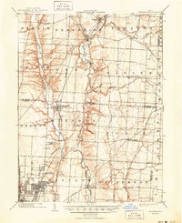
Big Walnut Creek and Alum Creek dominate the landscape of northern Franklin County at the turn of the century, carving through a region defined by established rural crossroads and emerging suburban trolley lines. The Akron Columbus and Cleveland Electric R. R. runs parallel to the western bank of the Walnut, connecting Westerville and Central College to the growing capital of Columbus to the south. This network of transportation reveals an era when local commerce still centered on small milling points like Parks Mills and Mifflinville, yet was increasingly influenced by the expansion of the rail systems.
Find a feature on this map
57 named features on this map. Tap any name to fly to it.
Don’t see what you’re looking for? This feature index may not catch every label — zoom into the map to look around manually.
Map Details
Editions of this 1902 Westerville Map
This is the sole edition of this map. No revisions or reprints were ever made.