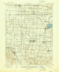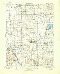
1907 Map of Thurston
USGS Topo · Published 1960About this map
Buckeye Lake, originally known as the Licking Reservoir, anchors the eastern landscape of this early twentieth-century survey. The area is defined by a dense intersection of early transportation infrastructure, including the National Road corridor and a complex grid of rail lines such as the Toledo and Ohio Central and the Baltimore and Ohio R R. Settlements like Basil, Baltimore, and Millersport serve as local hubs, while the Canal and Hocking Canal segments reflect an era of water-based transport that was being superseded by the rail network.
Find a feature on this map
63 named features on this map. Tap any name to fly to it.
Don’t see what you’re looking for? This feature index may not catch every label — zoom into the map to look around manually.
Map Details
Editions of this 1907 Thurston Map
This is the sole edition of this map. No revisions or reprints were ever made.