1909 Map of Thurston
USGS Topo · Published 1946About this map
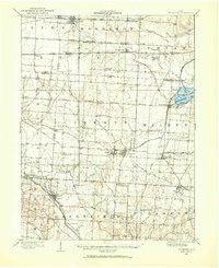
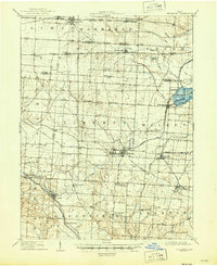
Buckeye Lake and its Reservoir Feeder dominate the eastern landscape of this Fairfield County survey, serving as a focal point for the surrounding agricultural townships. The region is defined by an intricate transportation network, where the historic National Road cuts across the north while a dense web of rail lines, including the Ohio Central Lines and the Hocking Valley R R, connect rural hubs. The map illustrates a period when small industrial and social centers flourished along these corridors, from the twin settlements of Basil and Baltimore to the Baltimore Campground and Lockville Sta. The presence of the Boundary Refugee Tract serves as a cartographic reminder of early 19th-century land grants. This survey captures the transition from a Canal based economy to one reliant on the steam engines of the Toledo and Ohio Central R R, which linked local grain and goods to wider markets.
Find a feature on this map
59 named features on this map. Tap any name to fly to it.
Don’t see what you’re looking for? This feature index may not catch every label — zoom into the map to look around manually.
Map Details
Editions of this 1909 Thurston Map
This is the sole edition of this map. No revisions or reprints were ever made.