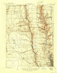
1903 Map of Dublin
USGS Topo · Published 1946About this map
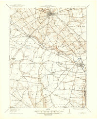
The Scioto River and Olentangy River carve parallel north-south valleys through this central Ohio landscape, defining the character of the settlements as they stood at the turn of the century. The map documents a critical period of railway expansion, where various trunk lines including the Pennsylvania System and the Toledo and Ohio Central R. R. intersect the rural townships of Washington, Liberty, and Jerome. While Columbus is visible at the southeastern edge, much of the area remains dominated by small farming hubs and railroad junctions. Genealogists and historians can trace the early footprints of communities like Dublin, Worthington, and Hilliard, along with smaller bypassed locales such as Rathbone and Hyattville. Significant water features like Hayden Run and Turkey Run feed into the primary river systems, highlighting the natural drainage patterns that influenced early homesteading and road placement before modern suburbanization.
Find a feature on this map
55 named features on this map. Tap any name to fly to it.
Don’t see what you’re looking for? This feature index may not catch every label — zoom into the map to look around manually.
Map Details
Editions of this 1903 Dublin Map
2 editions found
Other maps of this area

1901 · Dublin
USGS Topo · 1:62,500

1902 · Westerville
USGS Topo · 1:62,500

1903 · Dublin
USGS Topo · 1:62,500

1904 · Westerville
USGS Topo · 1:62,500
1907 · London
USGS Topo · 1:62,500
1913 · Richwood
USGS Topo · 1:62,500
1915 · Richwood
USGS Topo · 1:62,500

1915 · Marengo
USGS Topo · 1:62,500
1916 · Milford Center
USGS Topo · 1:62,500

1923 · West Columbus
USGS Topo · 1:62,500