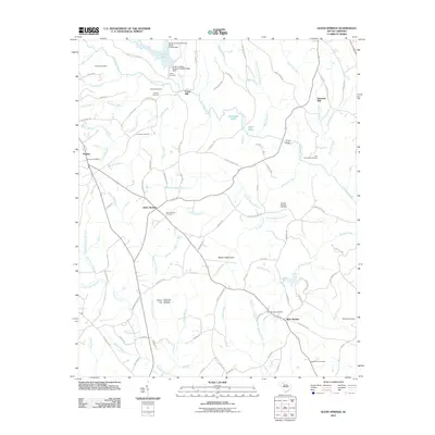
2011 Map of Glenn Springs
USGS Topo · Published 2011About this map
Glenn Springs and its surrounding countryside are defined by a dense network of family cemeteries and historic water-powered sites. The rural landscape is etched with the names of local lineages, as seen at the Foster Cemetery, Fleming Cemetery, and the Bogansville Cemetery. These markers, along with sites like Foster Mill and Kennedy Mill, trace a history of agrarian self-sufficiency and small-scale industry. To the south, Wofford Mountain rises over the headwaters of McElwain Creek and McClure Creek, while the settlement of West Springs serves as a crossroads for the local road network. The map reveals how the terrain influenced settlement, with early homesteads and churches like Antioch Cemetery established near dependable water sources such as Fairforest Creek and the many mineral-rich branches like Mineral Spring Branch and Sulphur Spring Branch.
Find a feature on this map
108 named features on this map. Tap any name to fly to it.
Don’t see what you’re looking for? This feature index may not catch every label — zoom into the map to look around manually.
Map Details
Editions of this 2011 Glenn Springs Map
This is the sole edition of this map. No revisions or reprints were ever made.
Other maps of this area

1941 · Spartanburg
USGS Topo · 1:250,000

1947 · Spartanburg
USGS Topo · 1:62,500

1949 · Spartanburg
USGS Topo · 1:24,000

1949 · Spartanburg
USGS Topo · 1:62,500

1953 · Spartanburg
USGS Topo · 1:250,000

1960 · Spartanburg
USGS Topo · 1:250,000

1963 · Spartanburg
USGS Topo · 1:250,000

1964 · Spartanburg
USGS Topo · 1:250,000

1969 · Cross Anchor
USGS Topo · 1:24,000
1969 · Pacolet Mills
USGS Topo · 1:24,000