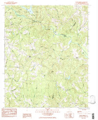
1983 Map of Glenn Springs
USGS Topo · Published 1983About this map
Croft State Park occupies the northern reaches of this landscape, where the waters of Fairforest Creek and Kelsey Creek converge near Lake Craig. The area's agricultural and social history is etched into the terrain through numerous family cemeteries and country churches, such as Antioch Cem and the Shiloh Ch. The settlement of Glenn Springs serves as a central point in a network of drainage basins, including the Mineral Spring Branch and Story Branch.
Find a feature on this map
60 named features on this map. Tap any name to fly to it.
Don’t see what you’re looking for? This feature index may not catch every label — zoom into the map to look around manually.
Map Details
Editions of this 1983 Glenn Springs Map
This is the sole edition of this map. No revisions or reprints were ever made.
Other maps of this area

1941 · Spartanburg
USGS Topo · 1:250,000

1947 · Spartanburg
USGS Topo · 1:62,500

1949 · Spartanburg
USGS Topo · 1:24,000

1949 · Spartanburg
USGS Topo · 1:62,500

1953 · Spartanburg
USGS Topo · 1:250,000

1960 · Spartanburg
USGS Topo · 1:250,000

1963 · Spartanburg
USGS Topo · 1:250,000

1964 · Spartanburg
USGS Topo · 1:250,000

1969 · Cross Anchor
USGS Topo · 1:24,000
1969 · Pacolet Mills
USGS Topo · 1:24,000