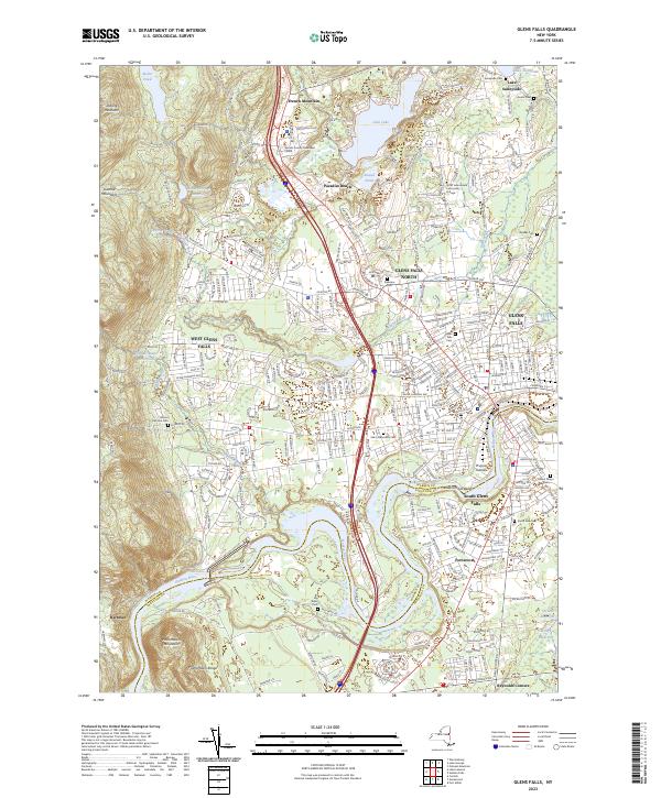
2023 Map of Glens Falls
USGS Topo · Published 2023About this map
The Hudson River carves a winding path across this modern landscape, serving as the historical and geographic boundary between Warren Co and Saratoga Co. Centered on the industrial and residential core of Glens Falls, the map illustrates a highly developed region where suburban expansion meets the rugged foothills of the Palmertown Range and French Mountain. This survey reveals the dense social fabric of the area through an extensive network of cemeteries, including the Glens Falls Cem, Saint Marys Cem, and the historic Quaker Cem, alongside major public institutions like SUNY Adirondack Community College. Water management remains a dominant feature of the landscape, evidenced by the series of reservoirs in the west such as the Keenan Intake Reservoir and Wilkie Intake Reservoir, which contrast with the recreational and residential clusters surrounding Glen Lake and Lake Sunnyside in the north.
Find a feature on this map
43 named features on this map. Tap any name to fly to it.
Don’t see what you’re looking for? This feature index may not catch every label — zoom into the map to look around manually.
Map Details
Editions of this 2023 Glens Falls Map
This is the sole edition of this map. No revisions or reprints were ever made.
Other maps of this area

1895 · Glens Falls
USGS Topo · 1:62,500

1897 · Glens Falls
USGS Topo · 1:62,500

1900 · Schuylerville
USGS Topo · 1:62,500

1902 · Saratoga
USGS Topo · 1:62,500

1903 · Luzerne
USGS Topo · 1:62,500

1935 · Gansevoort
USGS Topo · 1:24,000
1935 · Fort Miller
USGS Topo · 1:24,000

1935 · Corinth
USGS Topo · 1:24,000

1938 · Glens Falls
USGS Topo · 1:62,500
1940 · Schuylerville
USGS Topo · 1:62,500