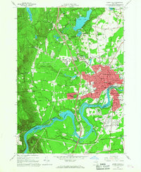
1966 Map of Glens Falls
USGS Topo · Published 1968About this map
The Hudson River carves a dramatic bend through this mid-1960s survey, separating Glens Falls in Warren County from South Glens Falls in Saratoga County. The industrial and hydroelectric character of the river is evident at the Feeder Dam and the Sherman Island Powerplant, while the expanding Adirondack Northway bisects the landscape, driving suburban growth toward West Glens Falls.
Find a feature on this map
98 named features on this map. Tap any name to fly to it.
Don’t see what you’re looking for? This feature index may not catch every label — zoom into the map to look around manually.
Map Details
Editions of this 1966 Glens Falls Map
This is the sole edition of this map. No revisions or reprints were ever made.
Other maps of this area

1895 · Glens Falls
USGS Topo · 1:62,500

1897 · Glens Falls
USGS Topo · 1:62,500

1900 · Schuylerville
USGS Topo · 1:62,500

1902 · Saratoga
USGS Topo · 1:62,500

1903 · Luzerne
USGS Topo · 1:62,500

1935 · Gansevoort
USGS Topo · 1:24,000
1935 · Fort Miller
USGS Topo · 1:24,000

1935 · Corinth
USGS Topo · 1:24,000

1938 · Glens Falls
USGS Topo · 1:62,500
1940 · Schuylerville
USGS Topo · 1:62,500