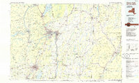
1986 Map of Glens Falls
USGS Topo · Published 1986About this map
The Hudson River carves a path through this mid-1980s landscape, serving as a corridor for established industrial and residential centers like Glens Falls, Hudson Falls, and Saratoga Springs. The map illustrates a region defined by the meeting of the Adirondack Mountains to the west and the Green Mountains and Taconic Range to the east. Transportation networks are prominent, featuring the Delaware and Hudson Railway and Interstate 87, which facilitate movement between the valley's manufacturing hubs and the seasonal recreation areas around Lake George.
Find a feature on this map
245 named features on this map. Tap any name to fly to it.
Don’t see what you’re looking for? This feature index may not catch every label — zoom into the map to look around manually.
Map Details
Editions of this 1986 Glens Falls Map
2 editions found
Other maps of this area

1889 · Wilmington
USGS Topo · 1:62,500

1891 · Wilmington
USGS Topo · 1:62,500

1891 · Rutland
USGS Topo · 1:62,500

1893 · Wallingford
USGS Topo · 1:62,500

1893 · Cohoes
USGS Topo · 1:62,500

1893 · Schenectady
USGS Topo · 1:62,500

1893 · Rutland
USGS Topo · 1:62,500

1893 · Fort Ann
USGS Topo · 1:62,500

1893 · Whitehall
USGS Topo · 1:62,500

1894 · Londonderry
USGS Topo · 1:62,500