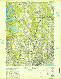
1944 Map of Glenville
USGS Topo · Published 1947About this map
The New York Connecticut state line divides this 1944 landscape, where the growing suburbs of Westchester and Fairfield counties meet established agricultural estates and institutional grounds. The Kensico Reservoir and Rye Lake dominate the western edge, while the interior is defined by massive private holdings like the Chieftains Estate and Sarasota Estate. This era shows the early influence of high-speed travel, with the Merritt Parkway and Hutchinson River Parkway cutting through the topography to connect these residential pockets.
Find a feature on this map
67 named features on this map. Tap any name to fly to it.
Don’t see what you’re looking for? This feature index may not catch every label — zoom into the map to look around manually.
Map Details
Editions of this 1944 Glenville Map
This is the sole edition of this map. No revisions or reprints were ever made.
Other maps of this area

1891 · Harlem
USGS Topo · 1:62,500

1892 · Stamford
USGS Topo · 1:62,500

1892 · Tarrytown
USGS Topo · 1:62,500

1893 · Stamford
USGS Topo · 1:62,500

1893 · Tarrytown
USGS Topo · 1:62,500

1897 · Harlem
USGS Topo · 1:62,500

1897 · Oyster Bay
USGS Topo · 1:62,500

1898 · Harlem
USGS Topo · 1:62,500

1898 · Oyster Bay
USGS Topo · 1:62,500

1899 · Stamford
USGS Topo · 1:62,500