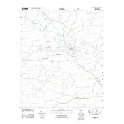
2011 Map of Glenwood
USGS Topo · Published 2011About this map
The Caddo River and its various forks anchor this West-Central Arkansas landscape, where the settlement of Glenwood serves as a central hub at the junction of several drainage systems. This 2011 survey reveals a region defined by its narrow valley roads and scattered community centers, such as Salem and Rosboro. For genealogists, the map is particularly rich with burial sites, including the Powers Chapel Cemetery and both the Ebenezer Cemetery and the Old Ebenezer Cemetery, providing specific geographic markers for family research in Montgomery County.
Find a feature on this map
111 named features on this map. Tap any name to fly to it.
Don’t see what you’re looking for? This feature index may not catch every label — zoom into the map to look around manually.
Map Details
Editions of this 2011 Glenwood Map
This is the sole edition of this map. No revisions or reprints were ever made.
Other maps of this area

1906 · Caddo Gap
USGS Topo · 1:125,000

1936 · Glenwood
USGS Topo · 1:48,000

1942 · Glenwood
USGS Topo · 1:62,500

1943 · Antoine
USGS Topo · 1:62,500

1949 · Glenwood
USGS Topo · 1:62,500

1955 · Little Rock
USGS Topo · 1:250,000

1956 · Little Rock
USGS Topo · 1:250,000

1960 · Little Rock
USGS Topo · 1:250,000

1964 · Little Rock
USGS Topo · 1:250,000
1966 · Bonnerdale
USGS Topo · 1:24,000