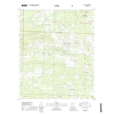
2020 Map of Glenwood
USGS Topo · Published 2020About this map
Glenwood serves as a central hub in this river-rich landscape where the Caddo River and its S Fork Caddo River converge. The terrain transitions from the heights of the Ouachita National Forest in the north, marked by peaks like Pigeon Roost Mtn and Reynolds Mtn, to the lowlands of Caney Valley along the Antoine River at the southern boundary. This topography dictated the settlement patterns of Montgomery and Pike counties, clustering small communities such as Salem and Rosboro along the valley floors. Genealogists will find a high density of rural burial grounds preserved in these hills, including Steller Cem, County Line Cem, and the Powers Chapel Cem. The map reveals a complex web of timber and forest roads connecting these isolated settlements to the larger towns, illustrating the enduring relationship between the local economy and the surrounding forest resources.
Find a feature on this map
115 named features on this map. Tap any name to fly to it.
Don’t see what you’re looking for? This feature index may not catch every label — zoom into the map to look around manually.
Map Details
Editions of this 2020 Glenwood Map
This is the sole edition of this map. No revisions or reprints were ever made.
Other maps of this area

1906 · Caddo Gap
USGS Topo · 1:125,000

1936 · Glenwood
USGS Topo · 1:48,000

1942 · Glenwood
USGS Topo · 1:62,500

1943 · Antoine
USGS Topo · 1:62,500

1949 · Glenwood
USGS Topo · 1:62,500

1955 · Little Rock
USGS Topo · 1:250,000

1956 · Little Rock
USGS Topo · 1:250,000

1960 · Little Rock
USGS Topo · 1:250,000

1964 · Little Rock
USGS Topo · 1:250,000
1966 · Bonnerdale
USGS Topo · 1:24,000