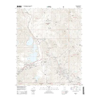
2014 Map of Globe
USGS Topo · Published 2014About this map
The copper mining corridor between Globe and Miami anchors this 2014 survey of Gila County, Arizona. The urban landscape reflects decades of industrial activity, with several distinct settlements including Lower Miami, Claypool, and Little Acres clustered along the major transportation routes of Us-60 and the Copper Basin Railway. The topographic detail highlights the massive scale of material movement in the region, evidenced by the Miami Tailings Pond and various canyons such as Warrior Canyon and Van Winkle Canyon. North of the urban centers, the terrain transitions into the Tonto National Forest, where named peaks like Ramboz Peak and Crash-up Mtn rise above the drainage of Pinal Creek. This sheet also captures community landmarks like the Bullion Plaza School and the somberly named Graveyard Canyon, providing a clear view of the area's social and industrial geography.
Find a feature on this map
164 named features on this map. Tap any name to fly to it.
Don’t see what you’re looking for? This feature index may not catch every label — zoom into the map to look around manually.
Map Details
Editions of this 2014 Globe Map
This is the sole edition of this map. No revisions or reprints were ever made.
Other maps of this area

1901 · Globe
USGS Topo · 1:62,500

1902 · Globe
USGS Topo · 1:62,500

1922 · Chrysotile
USGS Topo · 1:125,000

1945 · Globe
USGS Topo · 1:24,000

1945 · Inspiration
USGS Topo · 1:24,000

1947 · Inspiration
USGS Topo · 1:24,000

1948 · Pinal Ranch
USGS Topo · 1:24,000

1949 · Pinal Ranch
USGS Topo · 1:24,000

1949 · Rockinstraw Mtn
USGS Topo · 1:62,500

1950 · Rockinstraw Mtn
USGS Topo · 1:62,500