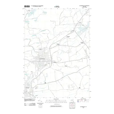
2010 Map of Gloversville
USGS Topo · Published 2010About this map
The manufacturing hub of Gloversville anchors this map of Fulton County, showing the dense street grid and industrial footprint of a city once synonymous with the American glove-making industry. The landscape transitions from the urban centers of Gloversville and Johnstown to the northern Adirondack foothills, where numerous reservoirs and lakes like Mountain Lake and Rice Reservoir dominate the higher elevations. This transition highlights the historical reliance on local water sources for industrial power and municipal supply.
Find a feature on this map
82 named features on this map. Tap any name to fly to it.
Don’t see what you’re looking for? This feature index may not catch every label — zoom into the map to look around manually.
Map Details
Editions of this 2010 Gloversville Map
This is the sole edition of this map. No revisions or reprints were ever made.
Other maps of this area

1895 · Amsterdam
USGS Topo · 1:62,500

1896 · Fonda
USGS Topo · 1:62,500

1898 · Fonda
USGS Topo · 1:62,500

1899 · Broadalbin
USGS Topo · 1:62,500

1902 · Broadalbin
USGS Topo · 1:62,500

1902 · Fonda
USGS Topo · 1:62,500

1903 · Gloversville
USGS Topo · 1:62,500

1931 · Amsterdam
USGS Topo · 1:62,500

1943 · Gloversville
USGS Topo · 1:62,500
1944 · Tribes Hill
USGS Topo · 1:24,000