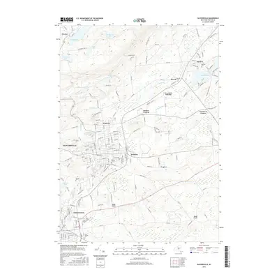
2016 Map of Gloversville
USGS Topo · Published 2016About this map
Gloversville and Johnstown anchor this landscape where industrial history meets the expansive waters of Great Sacandaga Lake. The urban grid transitions through the historic neighborhoods of Kingsboro and Berkshire into a rugged upland defined by vital water management systems, including the Ayres Hill Storage Reservoir, Port Reservoir, and Rice Reservoir. These reservoirs, along with Vandenburgh Pond and Ash Pond, underscore the region's historical reliance on local water sources for its manufacturing past.
Find a feature on this map
172 named features on this map. Tap any name to fly to it.
Don’t see what you’re looking for? This feature index may not catch every label — zoom into the map to look around manually.
Map Details
Editions of this 2016 Gloversville Map
This is the sole edition of this map. No revisions or reprints were ever made.
Other maps of this area

1895 · Amsterdam
USGS Topo · 1:62,500

1896 · Fonda
USGS Topo · 1:62,500

1898 · Fonda
USGS Topo · 1:62,500

1899 · Broadalbin
USGS Topo · 1:62,500

1902 · Broadalbin
USGS Topo · 1:62,500

1902 · Fonda
USGS Topo · 1:62,500

1903 · Gloversville
USGS Topo · 1:62,500

1931 · Amsterdam
USGS Topo · 1:62,500

1943 · Gloversville
USGS Topo · 1:62,500
1944 · Tribes Hill
USGS Topo · 1:24,000