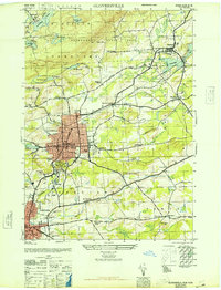
1946 Map of Gloversville
USGS Topo · Published 1946About this map
Gloversville and Johnstown anchor this mid-1940s landscape, illustrating the industrial and residential core of Fulton County before mid-century expansion. The urban centers are defined by established civic landmarks such as the Littauer Hospital, Armory, and City Hall, while the F J & G RR corridor marks the vital rail infrastructure of the era. Surrounding the urban grid are several historically significant burial grounds, including Prospect Hill Cem and St Patricks Cem.
Find a feature on this map
64 named features on this map. Tap any name to fly to it.
Don’t see what you’re looking for? This feature index may not catch every label — zoom into the map to look around manually.
Map Details
Editions of this 1946 Gloversville Map
This is the sole edition of this map. No revisions or reprints were ever made.
Other maps of this area

1895 · Amsterdam
USGS Topo · 1:62,500

1896 · Fonda
USGS Topo · 1:62,500

1898 · Fonda
USGS Topo · 1:62,500

1899 · Broadalbin
USGS Topo · 1:62,500

1902 · Broadalbin
USGS Topo · 1:62,500

1902 · Fonda
USGS Topo · 1:62,500

1903 · Gloversville
USGS Topo · 1:62,500

1931 · Amsterdam
USGS Topo · 1:62,500

1943 · Gloversville
USGS Topo · 1:62,500
1944 · Tribes Hill
USGS Topo · 1:24,000