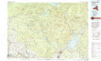
1985 Map of Gloversville
USGS Topo · Published 1994About this map
The Adirondack Park boundary dominates the northern half of this region, where the high peaks of the Adirondack Mountains like Snowy Mountain and Hamilton Mountain overlook a landscape defined by deep woods and isolated water bodies. In the south, the industrial corridor along the Mohawk River contrasts sharply with the wilderness, anchored by the manufacturing centers of Gloversville and Johnstown. The completion of the Great Sacandaga Lake serves as a major geographical focal point, supporting communities like Northville and Mayfield. Transport patterns follow the natural terrain, with the New York State Thruway and Conrail railroad lines hugging the river valley, while secondary routes like NY 8 and NY 10 wind north into the mountain interior toward Speculator and Piseco. This survey captures the mid-1980s balance between the concentrated urban development of Little Falls and the vast protected forests of the northern counties.
Find a feature on this map
111 named features on this map. Tap any name to fly to it.
Don’t see what you’re looking for? This feature index may not catch every label — zoom into the map to look around manually.
Map Details
Editions of this 1985 Gloversville Map
2 editions found
Other maps of this area

1893 · Schenectady
USGS Topo · 1:62,500

1895 · North Creek
USGS Topo · 1:62,500

1895 · Schenectady
USGS Topo · 1:62,500

1895 · Amsterdam
USGS Topo · 1:62,500

1896 · Fonda
USGS Topo · 1:62,500

1897 · North Creek
USGS Topo · 1:62,500

1897 · Remsen
USGS Topo · 1:62,500

1898 · Schenectady
USGS Topo · 1:62,500

1898 · Fonda
USGS Topo · 1:62,500

1898 · Thirteenth Lake
USGS Topo · 1:62,500