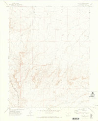
1970 Map of Goat Butte
USGS Topo · Published 1973About this map
Blake Ranch and the small settlement of Marnell anchor this 1970 landscape, where the high plains of southern Colorado meet the drainages leading toward the Arkansas River valley. The terrain is defined by an intricate network of seasonal watercourses, including Thomkins Creek, Edson Arroyo, and Sixmile Creek. The reliance on groundwater in this arid environment is evident through several named landmarks such as Lonesome Well, Peck Well, and Dry Lake Well. Industrial infrastructure is represented by the Denver and Rio Grande Western railroad corridor, which skirts the southwestern corner of the quadrangle. The map captures a moment of transition for this rural area, showing local connectivity via Doyle Road 5 Mi. and the prominent geological formation of Goat Butte, which serves as a significant landmark in the central portion of the survey.
Find a feature on this map
21 named features on this map. Tap any name to fly to it.
Don’t see what you’re looking for? This feature index may not catch every label — zoom into the map to look around manually.
Map Details
Editions of this 1970 Goat Butte Map
This is the sole edition of this map. No revisions or reprints were ever made.
Other maps of this area

1891 · Walsenburg
USGS Topo · 1:125,000

1891 · Pueblo
USGS Topo · 1:125,000

1891 · Nepesta
USGS Topo · 1:125,000

1891 · Apishapa
USGS Topo · 1:125,000

1893 · Nepesta
USGS Topo · 1:125,000

1893 · Apishapa
USGS Topo · 1:125,000

1894 · Walsenburg
USGS Topo · 1:125,000

1894 · Pueblo
USGS Topo · 1:125,000

1896 · Pueblo
USGS Topo · 1:125,000

1897 · Pueblo
USGS Topo · 1:125,000