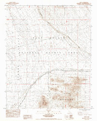
1984 Map of Goffs
USGS Topo · Published 1986About this map
Goffs stands as a vital crossroads in the high desert, where the heavy infrastructure of the American West converges. This 1980s landscape is defined by the Atchison Topeka and Santa Fe railroad, which cuts diagonally across the terrain, accompanied by a network of utilities including a Transmission Line, Gas Pipeline, and Underground Telephone Cable. The settlement is situated at the edge of the Fenner Valley and serves as a gateway to the East Mojave National Scenic Area. To the southeast, the topography rises sharply into the Piute Mountains, anchored by the prominent Goffs Butte. The wide, braided channel of Sacramento Wash dominates the northern reaches, illustrating the drainage patterns of this arid environment. The map details the transition from industrial transport corridors to the protected wilderness of the National Scenic Area Boundary.
Find a feature on this map
13 named features on this map. Tap any name to fly to it.
Don’t see what you’re looking for? This feature index may not catch every label — zoom into the map to look around manually.
Map Details
Editions of this 1984 Goffs Map
2 editions found
Other maps of this area

1886 · Camp Mohave
USGS Topo · 1:250,000

1892 · Camp Mohave
USGS Topo · 1:250,000

1910 · Ivanpah
USGS Topo · 1:250,000

1912 · Ivanpah
USGS Topo · 1:250,000

1926 · Mohave City
USGS Topo · 1:96,000

1942 · Camp Mohave
USGS Topo · 1:250,000

1942 · Ivanpah
USGS Topo · 1:250,000

1942 · Amboy
USGS Topo · 1:250,000

1943 · Amboy
USGS Topo · 1:250,000

1943 · Fenner
USGS Topo · 1:62,500