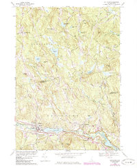
1969 Map of Goffstown
USGS Topo · Published 1985About this map
The Piscataquog River flows through the southern heart of this New Hampshire landscape, anchoring the bustling center of Goffstown and the neighboring community of Grasmere. In the late 1960s, this area reflects a mixture of established town life and expanding infrastructure, evidenced by the Maple Ave Sch, High Sch, and the presence of the Moore General Hospital. To the north, the terrain rises into the hills of Dunbarton and Bow, where smaller hamlets like Dunbarton Center and Baileys Corner are connected by winding rural routes such as Mansion Rd.
Find a feature on this map
66 named features on this map. Tap any name to fly to it.
Don’t see what you’re looking for? This feature index may not catch every label — zoom into the map to look around manually.
Map Details
Editions of this 1969 Goffstown Map
Other maps of this area

1905 · Manchester
USGS Topo · 1:62,500

1906 · Milford
USGS Topo · 1:62,500

1921 · Suncook
USGS Topo · 1:62,500

1927 · Concord
USGS Topo · 1:62,500

1941 · Manchester
USGS Topo · 1:62,500

1943 · Lowell
USGS Topo · 1:125,000

1943 · Fitchburg
USGS Topo · 1:125,000

1944 · Suncook
USGS Topo · 1:62,500

1948 · Boston
USGS Topo · 1:250,000

1949 · Portland
USGS Topo · 1:250,000