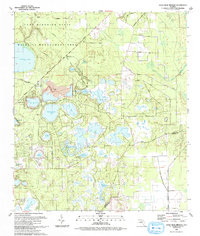
1993 Map of Gold Head Branch
USGS Topo · Published 1993About this map
Mike Roess State Park and the sprawling Camp Blanding State Wildlife Management Area dominate this section of the Florida lake district in the early 1990s. The landscape is characterized by a dense concentration of sinkhole lakes and ponds, ranging from the large Lowry Lake to the smaller Gator Bone Lake and Lake Margie. The map reveals a transition from the structured military and park boundaries in the west to the more scattered rural settlements in the east.
Find a feature on this map
53 named features on this map. Tap any name to fly to it.
Don’t see what you’re looking for? This feature index may not catch every label — zoom into the map to look around manually.
Map Details
Editions of this 1993 Gold Head Branch Map
This is the sole edition of this map. No revisions or reprints were ever made.
Other maps of this area

1915 · Interlachen
USGS Topo · 1:48,000

1916 · Interlachen
USGS Topo · 1:62,500

1938 · Hawthorn
USGS Topo · 1:48,000

1941 · Starke
USGS Topo · 1:62,500

1942 · Ates Creek
USGS Topo · 1:62,500

1943 · Hawthorn
USGS Topo · 1:62,500

1944 · Interlachen
USGS Topo · 1:62,500

1948 · Starke
USGS Topo · 1:50,000

1949 · Rice Creek
USGS Topo · 1:24,000

1949 · Baywood
USGS Topo · 1:24,000