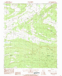
1983 Map of Golden City
USGS Topo · Published 1983About this map
Golden City and Earl Prairie anchor this early 1980s look at the Arkansas interior, where the valley of the Petit Jean River meets the northern boundary of the Ouachita National Forest. The map captures a transition between institutional land use and traditional rural settlement, featuring the Arkansas Childrens Colony and the Arkansas Dept of Corrections Prison Farm. Genealogists will find a high density of rural burial grounds, including Hopewell Cem, Logan Hall Cem, and Taylor Cem, alongside crossroads communities like Carolan. The southern half of the quadrangle is dominated by the steep rises of Montgomery Mountain and Huckleberry Mountain, where creeks like Right Hand Sugar Creek and Buck Knob Creek drain the timberlands towards the river valley.
Find a feature on this map
34 named features on this map. Tap any name to fly to it.
Don’t see what you’re looking for? This feature index may not catch every label — zoom into the map to look around manually.
Map Details
Editions of this 1983 Golden City Map
This is the sole edition of this map. No revisions or reprints were ever made.
Other maps of this area

1879 · Poteau Mountain
USGS Topo · 1:62,500

1887 · Poteau Mountain #1
USGS Topo · 1:62,500

1887 · Mount Ida #2
USGS Topo · 1:62,500

1887 · Magazine Mountain #3
USGS Topo · 1:62,500

1887 · Magazine Mountain
USGS Topo · 1:62,500

1890 · Magazine Mountain
USGS Topo · 1:125,000

1890 · Mount Ida
USGS Topo · 1:125,000

1890 · Fort Smith
USGS Topo · 1:125,000

1890 · Poteau Mountain
USGS Topo · 1:125,000

1899 · Poteau Mountain
USGS Topo · 1:125,000