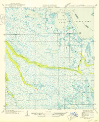
1950 Map of Golden Meadow Farms
USGS Topo · Published 1950About this map
Golden Meadow Farms sits at the heart of this coastal landscape, where the reclaimed marshland of Jefferson Parish and Lafourche Parish is defined by a complex network of drainage and transport. The map reveals the intricate water management required for early 20th-century agriculture and settlement in the wetlands, dominated by the Raphael Canal and Yankee Canal. These man-made waterways cut across natural features like Kings Ridge and the winding West Fork Bayou L'ours. To the north, the transition from marsh to open water is marked by large basins including Round Lake, Brusle Lake, and the expansive Little Lake. Local navigation is characterized by distinctively named reaches such as The Fool and Kings Bayou, illustrating how early residents and engineers navigated and reshaped the bayou country.
Find a feature on this map
16 named features on this map. Tap any name to fly to it.
Don’t see what you’re looking for? This feature index may not catch every label — zoom into the map to look around manually.
Map Details
Editions of this 1950 Golden Meadow Farms Map
This is the sole edition of this map. No revisions or reprints were ever made.
Other maps of this area

1892 · Barataria
USGS Topo · 1:62,500

1892 · Cut-Off
USGS Topo · 1:62,500

1892 · Creole
USGS Topo · 1:62,500

1894 · Lake Felicity
USGS Topo · 1:62,500

1935 · Bay Courant
USGS Topo · 1:31,680

1935 · Golden Meadow
USGS Topo · 1:31,680

1935 · Mink Bayou
USGS Topo · 1:31,680

1939 · Cut-Off
USGS Topo · 1:62,500

1939 · Lake Felicity
USGS Topo · 1:62,500

1941 · Cut-Off
USGS Topo · 1:62,500